GoldBee
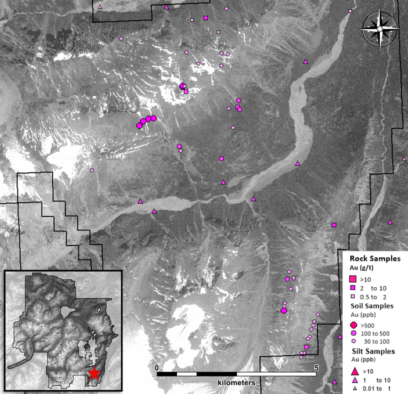
The GoldBee Target is the southern extension of the Golden Bear Mine trend. Gold mineralization is structurally controlled and hosted within Upper Triassic Stuhini Group volcanic and sedimentary rocks. Geochemical surveys and prospecting are planned.
South
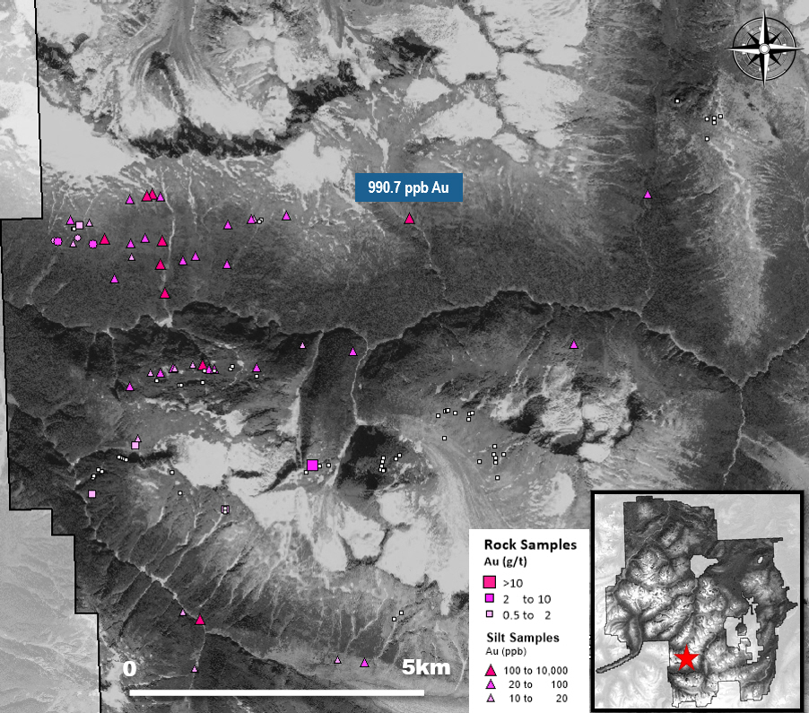
The South Target is located approximately 35 km south of the Trapper Target. Geology includes greenstones of the Whitewater Metamorphic Complex, coarse clastic sedimentary rocks of the Stikine Assemblage and Late Triassic quartz diorite intrusive rocks. Known mineralization includes vein-hosted chalcopyrite and disseminated pyrite and chalcopyrite, although only reconnaissance geochemistry surveys have been completed in the target area to date. The target includes one of the highest-grade gold samples in silts from the BC Regional Geochemical Survey, with 990.7 ppb Au and elevated Cu-Ag-As. The area around this sample has not yet been tested and geochemical surveys, prospecting and mapping are planned.
Terr
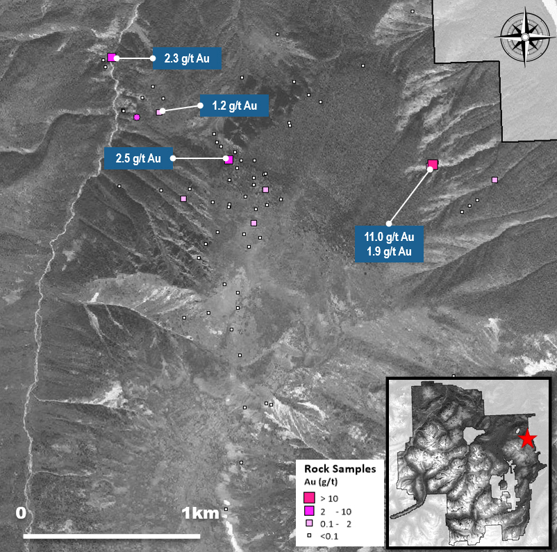
Terr is located along the western slopes of the Sheslay River, 30 km east of the Trapper Target. The area is mapped as predominantly Jurassic sedimentary rocks with Triassic and Cretaceous intrusions. There have only been two small-scale exploration programs reported at Terr, focused on mapping and prospecting. Mapping outlined widespread alteration within the sedimentary and intrusive rocks, associated with mineralized quartz vein samples and assays up to 11 g/t Au.
Plum
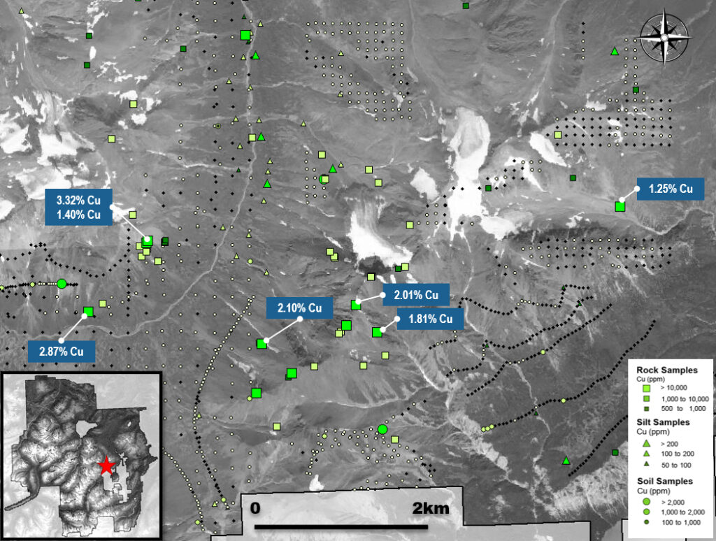
The Plum Target is located 8 km east of the Metla Target, immediately west of Tatsamenie Lake. The geology is dominated by Mississippian volcanic rocks of the Stikine assemblage, with local Lower Permian limestone. The aforementioned rocks are intruded by Triassic and Jurassic diorites and Eocene mafic dykes. Copper mineralization is vein-hosted with chalcopyrite and pyrite, including local chalcocite. This mineralization is found within broader zones of silica and pyrite alteration. Grab samples collected in 2020 found multiple occurrences with greater than 1% Cu, including one assay of 3.32% Cu.
Central (Moly-Valley)
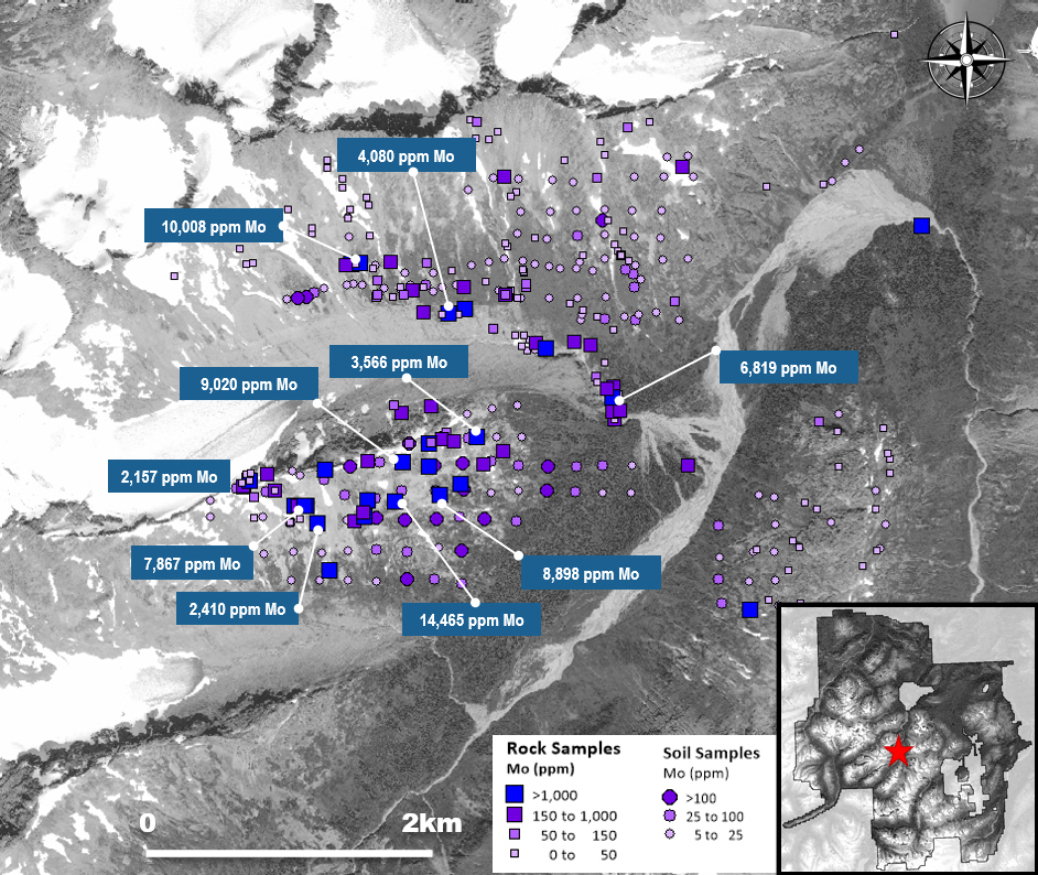
The Central Target is located 7km southwest of Metla. Similarly, the Central Target geology is dominated by plutonic rocks, with Middle to Late Triassic quartz-diorite intruded by granitic intrusive rocks of the Sloko-Hyder Plutonic Suite. At surface there are stockwork quartz-molybdenite-pyrite veins, as well as several historic drillholes. East-west trending sheeted veins, up to 1.5m thick, contain molybdenite, which is locally massive and contain grades up to 1.45% Mo.
Tat
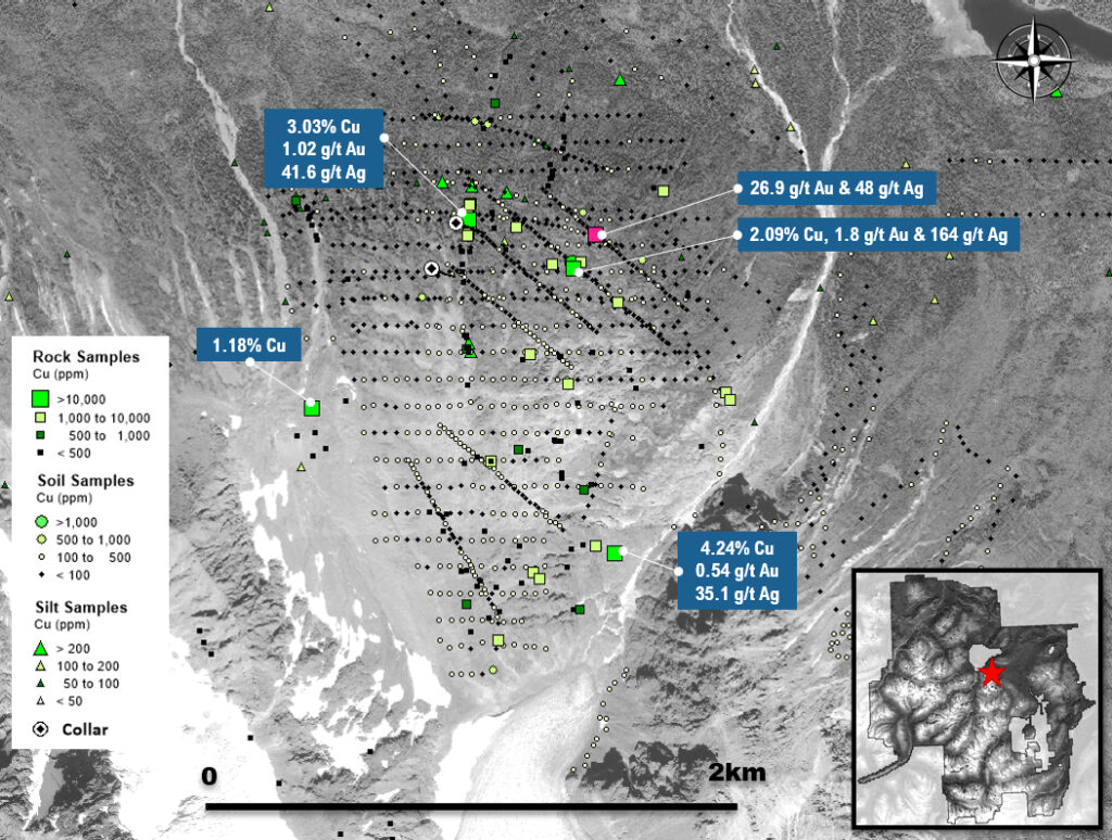
The Tat Au-Cu Target is 4km east of Trapper Lake, 11km east-southeast of the Trapper Target. Triassic Stuhini Group volcanic rocks are unconformably overlain by Jurassic Laberge Group sedimentary rocks. Quartz monzonites are also observed but of unknown age. The Tat Target was first worked in 1991 following the anomalous gold results reported from the BC Regional Geochemical Survey. Prospecting in the last 10 years have outlined a handful of chalcopyrite-pyrite showings with one sample assaying 4.24% Cu, 0.54 g/t Au and 35.1 g/t Ag. Other anomalous grab samples include 3.03% Cu, 1.02 g/t Au and 41.6 g/t Ag, and another at 2.09% Cu, 1.8 g/t Au and 164 g/t Ag. A small diamond drill program was completed in 2018-2019 targeting porphyritic alteration, although no significant mineralization was intersected.
Val
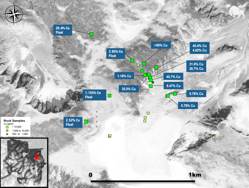
Val is a copper exploration target that was identified and explored in the 80’s, two kilometers south of the Triassic-Jurassic Red Line, 28 km east of the Trapper Target. This prospect is underlain by Triassic granodiorite, intruded by felsic Sloko Group dykes. Only two small rock and soil sampling programs have been conducted at this location, and prior to Brixton’s acquisition in 2022 no work had been documented since 1987. Rock sampling in 1980 identified a bornite-chalcocite bearing 20cm quartz vein, assaying 35% Cu and 228 g/t Ag. Follow-up sampling by Brixton in 2022 confirmed the presence of the vein with assays up to 40.7% Cu, and a confirmed strike length of over 250 meters. Two copper-bearing, sub-parallel veins were also identified 50m and 100m northwest of the main vein with values of >50% Cu and 45.4% Cu respectively.
North
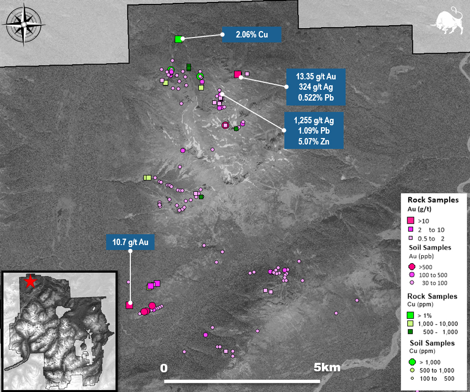
The North Target covers the region 6 to 12 km north of Brixton’s Thorn Camp, northwest of the Sutlahine River. The area is underlain by Jurassic aged volcanic and sedimentary rocks of the Labegre Group, intruded by Cretaceous and Eocene quartz feldspar porphyry dykes and sills. Anomalous Au-Ag-Cu-Pb-Zn has been sampled across this large area, associated with skarn, porphyry, polymetallic veining and sedimentary-hosted mineralization settings. A 20cm chip sample collected in 2004 assayed 13.35 g/t Au and 324 g/t Ag. The North target area has not yet been drill tested.
East
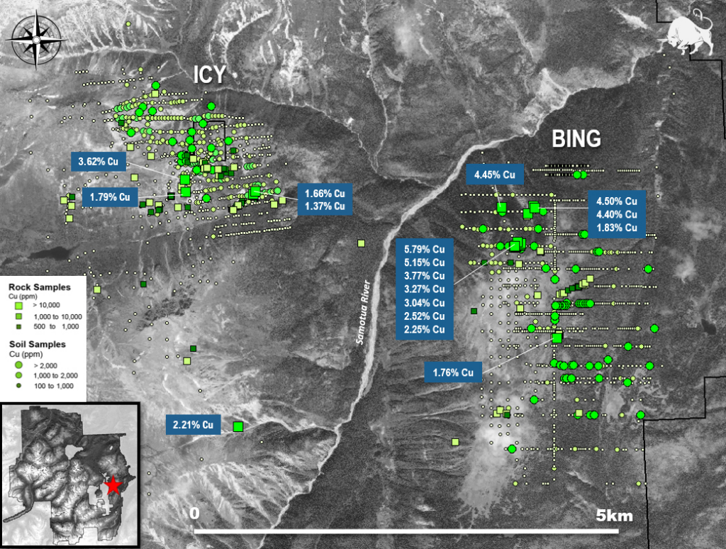
The East Target is located 25km east of Metla and 17km north-northeast of the Golden Bear Mine. The geology is dominated by Middle to Late Triassic quartz diorite and granodiorite intrusive rocks, with windows of Stuhini Group volcanic rocks. There are two main copper showings on either side of the Samotua River.
The Bing showing is on the east side of the river and includes widespread copper and molybdenum mineralization, as disseminations and within veining stockworks. Historic drilling did not target the area hosting the most anomalous samples to the north, where a cluster of 10 samples have grades greater than 2% copper over a 500m x 500m area. Surface rock samples collected in 2022 returned up to 5.79% Cu. Over 200 soil samples were collected at Bing in 2022, and results were promising with 16 samples greater than 1000 ppm Cu and highly anomalous values of 9,610 ppm Cu and 7,290ppm Cu collected at the south end of the zone.
The Icy showing is to the west and includes a 2km x 800m gossan with associated copper soil anomaly. Copper values in rocks reach up to 3.62% Cu. Rio Tinto Only minimal work has been conducted on this target since RioTinto.
Outlaw
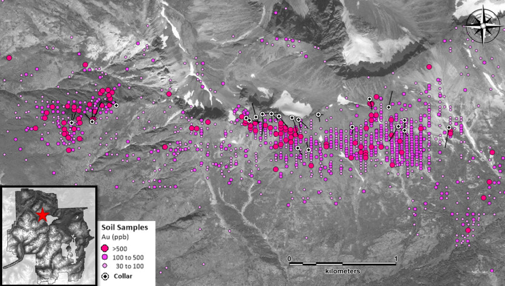
The Outlaw Zone is composed of sediment-hosted (siltstone-greywacke-argillite-carbonates) Au-Ag related to pyrite and pyrrhotite veins, and stratiform disseminated to semi-massive pyrite and pyrrhotite. Mineralized horizons may be related to the Jurassic-aged felsic dykes, suggesting the mineralization is intrusion-related. The gold-in-soil anomaly is over 4 kilometers long. Drill testing has shown that this gold horizon occurs at depth through the central part of the Outlaw Target, over a 600m strike length. Hole THN14-128, drilled in the Central Outlaw area, returned 59.65m of 1.15 g/t Au. Surface rocks samples have returned up to 22.9 g/t Au from East Outlaw and 68.8 g/t Au from West Outlaw.
