December 1, 2023 – Brixton Metals Corporation (TSX-V: BBB, OTCQB: BBBXF) (the “Company” or “Brixton”) is pleased to announce the final batch of 2023 drill results from the Trapper Gold Target at its wholly owned Thorn Project. The project is located in Northwest British Columbia, 90km east of Juneau, Alaska and within the Taku River Tlingit and Tahltan First Nation’s traditional territory.
Highlights
- Ten visible gold occurrences observed across four drill holes
- Hole THN23-287 yielded 276.00m of 0.34 g/t Au from 12.00m depth
- Including 149.00m of 0.55 g/t Au
- Including 54.00m of 1.03 g/t Au
- Including 19.00m of 2.34 g/t Au
- Hole THN23-288 yielded 179.50 of 0.51 g/t Au from 9.00m depth
- Including 76.50m of 1.08 g/t Au
- Including 6.00m of 4.58 g/t Au
- And Including 17.00m of 2.51 g/t Au from 90.00m depth
Chairman and CEO, Gary Thompson, stated, “We are delighted to see the gold mineralization encountered in drilling as we step away from the previous drilling. A nearly 2km gap remains to be tested through drilling between this main area to the southeast where previous operators drilled 1.78 g/t Au over 32.67m including visible gold. The Trapper Target represents a 4km gold-in-soil anomaly with limited drilling to date. In addition, a new copper showing was discovered with disseminated bornite located 5km south of the Trapper main drilling area. Highlights from South Trapper include 6.5% and 5.3% Cu from rock grab samples which will be followed up in 2024.”
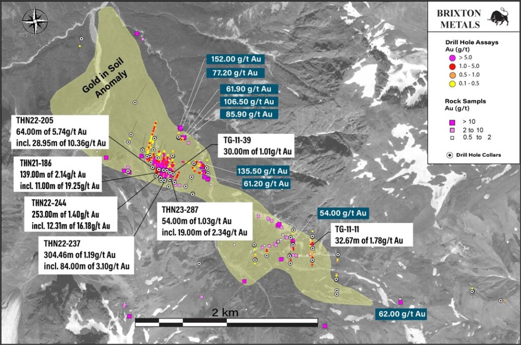
Figure 1. Gold Geochemistry and Trapper Target Location Map.
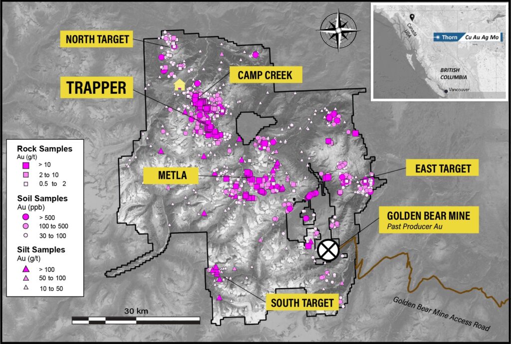
Table 1. Select Mineralized Intervals for the Trapper Target Drilling.
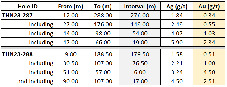
All assay values are uncut weighted averages and intervals reflect drilled lengths as further drilling is required to determine the true widths of the mineralization.
Discussion
The 2023 program at the Trapper Gold Target totaled 6,625.24m of drilling. This News Release covers 3,598.24m of drilling for a total of 11 drill holes. For previous assays from the 2023 program at Trapper see NR dated October 16th, 2023.
Figure 2. Simplified Geology Map with Collar Locations and Drill Traces at the Trapper Target.
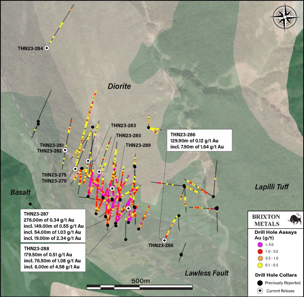
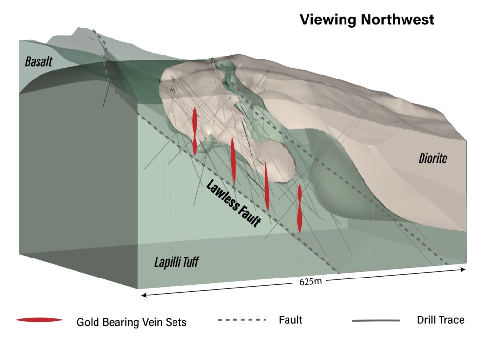
Gold mineralization at Trapper is structurally controlled along the Lawless fault, trending northwest-southeast and dipping moderately to the north. Mineralization appears to favour the contact between the Cretaceous (85.2 +/- 1.2Ma) quartz diorite and the Triassic lapilli tuffs with broad gold intervals largely hosted along the faulted contact. The gold is associated with silver and base metal veins containing pyrite-galena-sphalerite +/- chalcopyrite +/- bornite, which occur conjugate to the Lawless fault. Through a combination of oriented core drilling, surface mapping, geochemistry and geophysics, the aim is to achieve predictability of the gold-bearing zones. The current drilling at the Trapper Target is located 7km southeast from the Camp Creek Copper Porphyry Target. At surface, the Trapper Target is expressed as a 4km northwest trending gold and zinc soil geochemical anomaly which is part of the larger 11km gold geochemical anomaly trending from Camp Creek to the Trapper Target.
The 2023 drill campaign at Trapper was designed to test the extents of the main mineralized corridor along the Lawless fault zone, as well as testing step-out targets where similar structural and geophysical features were interpreted using the high-resolution aeromagnetic survey completed in 2022. Drilling was planned through a combination of mapping, oriented core data analysis, geophysics, and soil geochemistry. Results from the 2023 drill program continue to demonstrate the potential for broad intercepts of near surface gold mineralization which remains open in several directions.
Figure 3. 3D Conceptual Deposit Model of the Trapper Gold Target, Northwest View.
Drill holes THN23-275 and THN23-279 were collared from the same drill pad as previously released hole THN23-278 (assaying 123.58m of 0.15 g/t Au from 347.50m) and were planned to test the western extents of mineralization in the hanging-wall along the Lawless fault and around the intrusive-volcanic contacts. Although no significant assays were achieved with holes THN23-275 and THN23-279, base metal mineralization and two instances of visible gold were observed in discrete vein sets and appear to be distal extents of the main gold-rich zone to the east. Additionally, THN23-278 from this pad location was successful in extending the mineralized zone approximately 250m down dip and towards the north along the Lawless fault.
THN23-280 was collared 120m north of THN22-205 (assaying 64.00m of 5.74 g/t Au, including 28.95m of 10.36 g/t Au) and planned as a northern step-out hole to test the lapilli tuff and quartz diorite contacts. THN23-280 was drilled to a total depth of 399m with one visible gold occurrence returning 0.40m of 3.54 g/t Au, however no significant assay intervals were achieved.
Drill holes THN23-281 and THN23-282 were collared from the same drill pad, located 100m northwest of THN23-275, and were planned to test the far west extents of mineralization along the Lawless fault. THN23-281 was drilled towards the north targeting the dominant base metal vein orientations while THN23-282 was drilled towards the south to test additional conjugate vein orientations within the Stuhini volcanics. Although THN23-281 was relatively unmineralized, discrete occurrences of base metal mineralization with low-grade gold intercepts up to 2.57 g/t Au over 1.0m were observed at depth proximal to the fault zone. No significant mineralization was observed in THN23-282.
THN23-283 was drilled 200m north of THN22-205 and planned as a northern step-out to test for mineralization along the lower contact zone of the lapilli tuff and quartz-diorite. THN23-283 was drilled towards the north to a final depth of 433m and no significant mineralization was observed.
THN23-284 was collared ~600m north-northwest of the main drilling zone at Trapper and planned to test an undercover area with a gold-in-soil anomaly sharing a similar geophysical signature to the main zone which was identified from the 2022 aeromagnetic survey. THN23-284 was drilled towards the northeast to a final depth of 345m and although intercepting quartz-carbonate veining with base metal mineralization and a similar alteration assemblage to the main zone, no significant gold grades were returned. Further drilling is required around THN23-284 to determine the extents of epithermal mineralization and potential gold-bearing structures in this area.
THN23-286 was collared ~150m east of the main drilling area to test the eastern extension of mineralization along the Lawless fault in an area of anomalous gold and zinc-in-soil. The hole was drilled to a final depth of 171m and intersected short intervals of epithermal style veining with pyrite-sphalerite-galena-chalcopyrite base metal mineralization within the lapilli tuff. Assays include 129.90m of 0.12 g/t Au, including 7.90m of 1.64 g/t Au.
Drill holes THN23-287 and THN23-288 were collared from the same pad location, setup as 40m step-out holes between THN22-237 (assaying 84.00m of 3.10 g/t Au) to the southwest and historic 2011 drill holes to the east. Both holes were planned to test the extents of mineralization to greater depths along the Lawless fault while testing the lapilli tuff and quartz diorite contacts. THN23-287 was drilled at a -62 degree dip towards the north and was successful in intercepting base metal sulphide mineralization with five visible gold occurrences assaying 54.00m of 1.03 g/t Au, within 149.00m of 0.55 g/t Au.
THN23-288 was drilled below THN23-287 at a -80 degree dip to test the continuity of mineralized veins at depth and towards the south. Two visible gold occurrences were observed along with numerous base metal sulphide veins assaying 179.50m of 0.51 g/t Au from 9.00m depth, including 76.50m of 1.08 g/t Au, and including 17.00m of 2.51 g/t Au from 90.00m depth.
THN23-289 was collared 120m northwest of THN23-287 and THN23-288 as step-out hole planned to target the intrusive-volcanic contact north of the Lawless fault. Minor quartz-carbonate base-metal veining was observed in core however no visible gold was observed and no significant assays were returned.
Figure 4. Visible Gold Photographs of 2023 Trapper HQ Core.
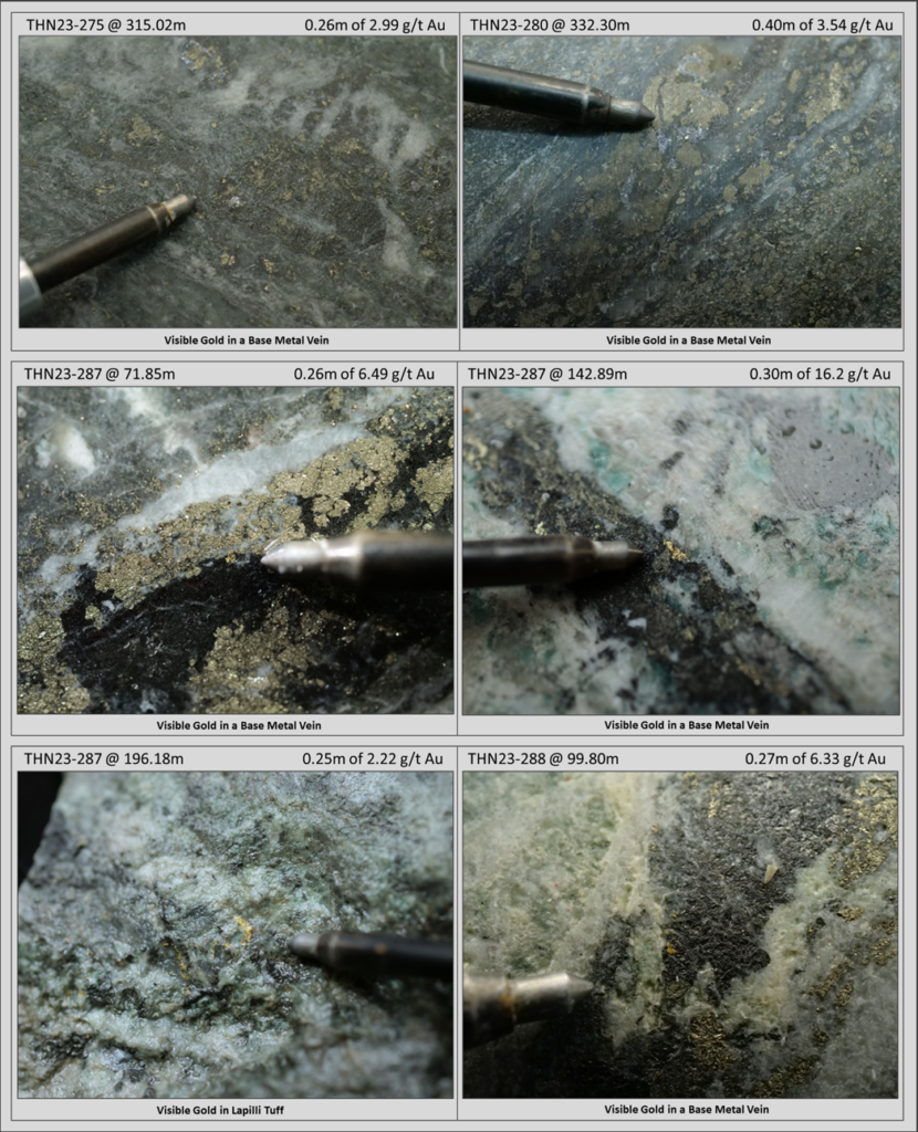
Figure 5. Gold Surface Geochemistry Map with Collar Locations and Drill Traces at the Trapper Target.
2023 Trapper Drill Campaign Summary
The 2023 exploration program at Trapper was designed to test areas proximal to the main drilling zone in order to determine the extents of gold-bearing ore shoots along the Lawless fault, as well as test undercover outboard areas hosting similar geophysical and soil geochemical signatures to the main zone. Drilling was successful in expanding upon the past two seasons of drilling around the main zone, however additional work is needed around the larger step out zones to help uncover potential areas of high-grade gold mineralization. While Trapper is largely undercover, the gold-in-soil geochemical footprint extends 4km by 1.5km and remains largely undrilled. High-grade surface grab samples have returned assays up to 152 g/t Au along Inlaw Creek, over 500m away from the focused drilling area. Further drilling is required to test and identify gold-rich zones and further define the scale-potential across the Trapper Target.
Vice President of Exploration, Christina Anstey, stated, “While we now have three seasons of drilling under our belt at Trapper Gold Target, we believe that we are only getting started with uncovering the gold potential and we are looking forward to advancing the target further in 2024”.
Drilling Information
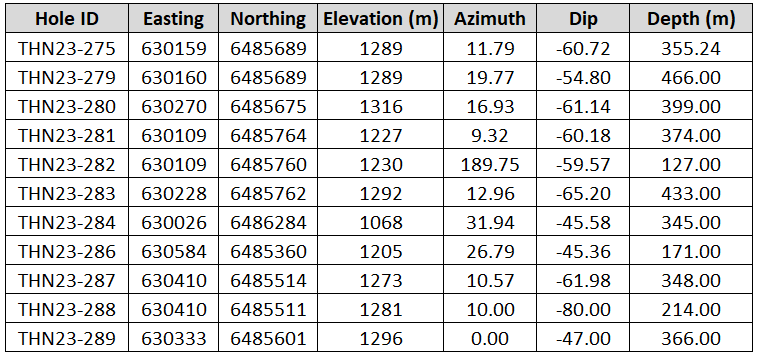
Table 2. Drill Collar and Hole Information of Current News Release.
About the Trapper Gold Target
The geochemical footprint for the Trapper Gold Target was expanded in 2021 to 4km by 1.5km with a gold-in-soil geochemical signature that has a strong positive correlation to zinc and lead. The Trapper Target represents an intermediate-sulphidation epithermal system hosted in volcanic and intrusive rocks. The volcanics are Triassic Stuhini lapilli tuff, while the intrusive phase is a Cretaceous quartz diorite dated at 85.2Ma +- 1.2Ma. Visible gold has been identified in both drill core and surface outcrops across the Trapper Target area and rock grab samples have returned up to 152 g/t Au. Visible gold is recognized in several environments: within base metal veins (sphalerite-galena-pyrite-chalcopyrite), quartz-stockwork, sulphosalt-pyrite veinlets, and rarely disseminated gold in the diorite. In 2021 and 2022, Brixton drilled 3,107m and 9,119m respectively. In 2011, forty-two drill holes were completed by a previous operator. The Trapper Target is royalty free.
Quality Assurance & Quality Control
Quality assurance and quality control protocols for drill core sampling was developed by Brixton. Core samples were mostly taken at 1.0m intervals. Blank, duplicate (lab pulp) and certified reference materials were inserted into the sample stream for at least every 20 drill core samples. Core samples were cut in half, bagged, zip-tied and sent directly to ALS Minerals preparation facility in Langley, British Columbia. ALS Minerals Laboratories is registered to ISO 9001:2008 and ISO 17025 accreditations for laboratory procedures. Samples were analyzed at ALS Laboratory Facilities in North Vancouver, British Columbia for gold by fire assay with an atomic absorption finish, whereas Ag, Pb, Cu and Zn and 48 additional elements were analyzed using four acid digestion with an ICP-MS finish. Over limits for gold were analyzed using fire assay and gravimetric finish. The standards, certified reference materials, were acquired from CDN Resource Laboratories Ltd., of Langley, British Columbia and the standards inserted varied depending on the type and abundance of mineralization visually observed in the primary sample. Blank material used consisted of non-mineralized siliceous landscaping rock. A copy of the QAQC protocols can be viewed at the Company’s website.
About the Thorn Project
The wholly-owned 2,881 square kilometer Thorn Project is located in British Columbia, Canada, approximately 90 km east of Juneau, AK. The southern limit of the Thorn claim boundary is roughly 50 km from tide water. The Thorn Project hosts a district-scale 80km megatrend of Triassic to Eocene, volcano-plutonic complex with several styles of mineralization related to porphyry and epithermal environments. Fourteen large-scale copper-gold targets have been identified for further exploration work. Information on each of the targets may be found at the following link: https://brixtonmetals.com/thorn-gold-copper-silver-project/
Qualified Person
Mr. Corey A. James, P.Geo., is a Senior Project Geologist for the company and a qualified person as defined by National Instrument 43-101. Mr. James has verified the data disclosed in this press release, including the sampling, analytical and test data underlying the technical information and has approved this press release.
About Brixton Metals Corporation
Brixton Metals is a Canadian exploration company focused on the advancement of its mining projects toward feasibility. Brixton wholly owns four exploration projects: Brixton’s flagship Thorn copper-gold-silver-molybdenum Project, the Atlin Goldfields Project located in NW BC, the Langis-HudBay silver-cobalt-nickel Project in Ontario, and the Hog Heaven copper-silver-gold Project in NW Montana, USA (under option to Ivanhoe Electric Inc.). Brixton Metals Corporation shares trade on the TSX-V under the ticker symbol BBB, and on the OTCQB under the ticker symbol BBBXF. For more information about Brixton, please visit our website at www.brixtonmetals.com.
On Behalf of the Board of Directors
Mr. Gary R. Thompson, Chairman and CEO
Tel: 604-630-9707 or email: info@brixtonmetals.com
Neither the TSX Venture Exchange nor its Regulation Services Provider (as that term is defined in the policies of the TSX Venture Exchange) accepts responsibility for the adequacy or accuracy of this release.
Information set forth in this news release may involve forward-looking statements under applicable securities laws. Forward-looking statements are statements that relate to future, not past, events. In this context, forward-looking statements often address expected future business and financial performance, and often contain words such as “anticipate”, “believe”, “plan”, “estimate”, “expect”, and “intend”, statements that an action or event “may”, “might”, “could”, “should”, or “will” be taken or occur, including statements that address potential quantity and/or grade of minerals, potential size and expansion of a mineralized zone, proposed timing of exploration and development plans, or other similar expressions. All statements, other than statements of historical fact included herein including, without limitation, statements regarding the use of proceeds. By their nature, forward-looking statements involve known and unknown risks, uncertainties and other factors which may cause our actual results, performance or achievements, or other future events, to be materially different from any future results, performance or achievements expressed or implied by such forward-looking statements. Such factors include, among others, the following risks: the need for additional financing; operational risks associated with mineral exploration; fluctuations in commodity prices; title matters; and the additional risks identified in the annual information form of the Company or other reports and filings with the TSXV and applicable Canadian securities regulators. Forward-looking statements are made based on management’s beliefs, estimates and opinions on the date that statements are made and the Company undertakes no obligation to update forward-looking statements if these beliefs, estimates and opinions or other circumstances should change, except as required by applicable securities laws. Investors are cautioned against attributing undue certainty to forward-looking statements.